
Report to KwaZulu-Natal MEC for Transport, Community Safety & Liaison Mr Willies Mchunu MPL
Recommendation to restrict the use of M13/Field's Hill by heavy vehicles, 12/10/2011
Submitted by Field's Hill Task Team:
Mr Siboniso Mbhele - General Manager - Operations: Durban, KZN Department of Transport (DOT) Mr Gerald Perumal - Manager: Durban Region, KZN Department of Transport (DOT)
Mr SS Nxumalo - Regional Commander, KZN Road Traffic Inspectorate (RTI)
Mr Andre Horner - Station Commander (Pinetown), KZN Road Traffic Inspectorate (RTI) Cllr Warwick Chapman - Ward Councillor, eThekwini
Mr Paulos Ngcobo - Director, Beier Safety Footwear
Mr Wolfgang Beier - Managing Director, Beier Industries
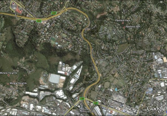
1.1. Specific Area of Concern: Field's Hill
The section of the M13 known as Field's Hill runs from the Richmond Rd/M13 intersection in Pinetown in the South to the Pioneer Rd/M13 Intersection in Kloof in the North.
1.2. General Area of Concern: Richmond/M13 to Kassier/M13
The M13 from Richmond Rd (Pinetown) to Kassier Rd (Shongweni) is also of concern because of damage to the road caused by overloaded and heavy vehicles using this road instead of the N3.
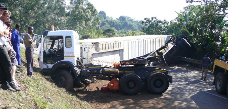
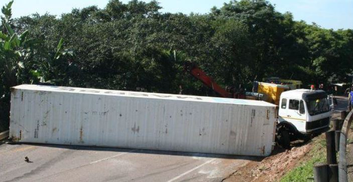
Field's Hill has a reputation as being a dangerous section of road and has been the site of many fatal and damaging accidents. The accident records of the past 10 years show a dramatic increase in the number and severity of accidents on the route, especially those accidents including heavy vehicles.
In 2009 it was established in a cost comparison study that the M13 route is more expensive than N3 for many classes of heavy vehicle and the cost difference negligible for the rest. The cost of maintaining the M13 is higher than it should be as a result of the damage caused by heavy and overloaded vehicles which it is not capable of carrying due to lower standard geometry, capacity problems and inadequate regular maintenance.
The cost in lives, damage to infrastructure and the economic impact of reduced productivity, while difficult to calculate, must far exceed any cost benefit of using the M13 instead of the safer, purpose built N3.
The superior alignment, gradients and sight distances of the purpose designed N3 toll road reduces the risk of accident significantly and should therefore be the preferred route for heavy vehicles and not the M13.
3.1. Daily Volumes of Large (10-30t) Heavy Vehicles)
An indicative survey of heavy vehicle traffic volumes (Appendix F1 & F2) was done on 15-17 September 2010 by Beier Industries. New daily heavy vehicle counts over the three days 15 - 17 Sept 2010 of the Field's Hill westbound (uphill) and eastbound (downhill) carriageways show the following:
1. Similar numbers of trucks in the 10 - 16 ton and 16 - 30 ton capacities in each direction in the range 226 - 347 heavy vehicles per 10 hour day.
2. The busiest day was the Friday with the total downhill truck count of 620 trucks in the 10 hour period, which are fairly uniformly spread with 7 - 12 % being counted per hour, including the morning and afternoon peaks.
3. The above clearly shows that between 07:30 and 09:30 on Friday 17 September 2010 some 63 very heavy trucks in the load group 16 - 30 tons came down Field's Hill, which could have been avoided if these trucks had been diverted to the safer N3. Similar but slightly lesser heavy truck flows occurred on the previous two days, and also with comparable figures in the uphill direction.
3.2. Daily Volumes 2001-2010 (eThekwini Transport Authority)
The eThekwini Transport Authority surveys traffic volumes once every two years. These volumes are indicative of the sort of traffic volume which may be experienced and do seem to provide a sensible reflection of traffic volume.
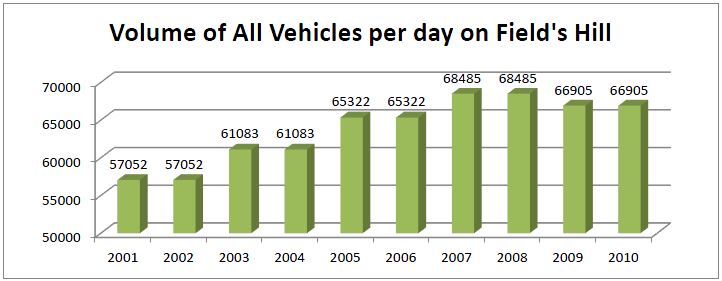
Traffic volumes peaked in 2007/8 before the economic crisis of late 2008 and accordingly are indicated to have reduced slightly in 2009/10.

Heavy vehicle volumes experienced a 180% increase from 1980 heavy vehicles per day in 2001/2 and the peak of 3592 heavy vehicles per day in 2005/6, thereafter reducing marginally to 3406 for 2007/8 and fractionally to 3359 in 2009/10.
4. Operating Cost Comparison of M13 and N3
An operating cost comparison (Appendix B) of a similar nature to those commissioned by the concessionaires operating the N4 (TRAC) and N3 between Cedara and Heidelberg (N3TC) was conducted recently at the request of local businesses has found that "in most cases the cost of operating a vehicle is lower on the N3 Toll route than on the M13".
The cost comparison compares different classes of vehicle, with differing loads and travelling in both directions over the stretch of both roads from Grayleigh (Westville side of Cowie's Hill) to Key Ridge (Shongweni). The M13 route is 24.6km and the N3 route 22.5km. For example, a 6x4 truck-tractor and interlinks travelling with a full load on the M13 costs 5.4% more than using the N3 (R397.85 vs R376.29 respectively).
Overall, when taking into account the total sample of heavy vehicles used in the study, the M13 is on average 1.55% more expensive to use than the N3. The cost to the national economy and our energy bill of 1.55% for every heavy vehicle which chooses the M13 over the N3 will result in many millions of Rands being wasted.
Accident data maintained by the eThekwini Transport Authority confirms there has been dramatic increase in accidents on Field's Hill. A sample of data secured from the eThekwini Transport Authority Data Analysis office (Appendix E) provides accident data for the stretch of the M13 known as Field's hill from the Ridge Rd bridge (Pioneer Rd) at the top of Field's Hill to the Richmond Rd bridge at the bottom of the hill during the decade 2001-2010.
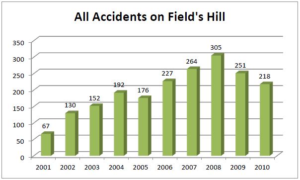
Accidents of all vehicle classes experienced a nearly 450% increase from a low of 67 in 2001 to a high of 305 in 2008, and across the entire sample of accident data, were 325% times higher at 218 in 2010 than in 2001.
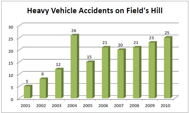
Heavy vehicle accidents have steadily increased by 500% from 5 in 2001 to 25 in 2010, peaking at 26 in 2004.
The improvement from 2008 to 2010 in the figures for all vehicles is likely a result of time restrictions applied for use by heavy vehicles and improved enforcement of the forced stop at the top of the hill. However, the permanent enforcement of heavy vehicles on this stretch of road draws significant resource from both the Durban Metro Police and the KZN Road Traffic Inspectorate and despite this, the accident statistics remain extremely high when compared with the beginning of the decade.
***
***
6. Safety
The report referred to above (Appendix B) shows that the figures indicated in the report are not able to take into account the additional risk-related cost savings of the "relative safety of the toll road".
The risk of using the M13 as opposed to the N3 "cannot easily be quantified and the effect of the unsafe road will only happen at random... [as] a tyre blowout, suspension damage or maybe even a serious accident. Any of these incidents would totally negate any perceived cost saving that may be gained out of evading toll fees."
The report concludes that another difficult factor to quantify is the negative effect of driver fatigue - a pertinent factor when considering the impact of heavy vehicle. The report closes stating, "that a driver using the toll route will stay alert very much longer and thus be less prone to having an accident."
Listed below are several factors which contribute to making the M13, and the Field's Hill section in particular, more dangerous than the N3. While each of the factors are a potential accident hazard on their own, they are often combined on Field's Hill and lead to the high accident rate over this section.
6.1. Visibility, Gradients and Speeding
The gradient of Field's Hill is generally 7.5% and the speed of a fully laden heavy vehicle travelling up the hill at that gradient is between 18 and 24 kilometres per hour. This creates a speed differential of perhaps 60 kilometres per hour between an average light motor vehicle and a heavy vehicle. Speed differentials in both uphill and downhill directions are frequent causes of accidents, particularly if evasive action has to be taken.
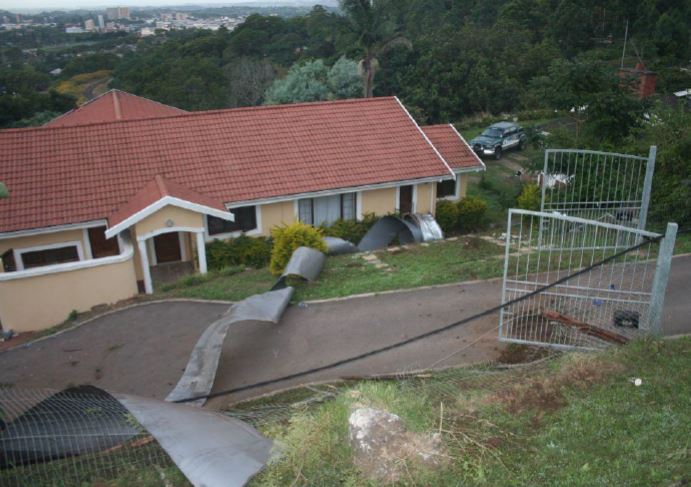
A particular problem in the descent of Field's Hill is the sub-standard radius of the first sharp right hand curve (See westbound in Figure 1 below), where numerous heavy vehicle accidents have occurred over the years. The adjoining residential properties have been encroached upon by trucks leaving the road and climbing over the purpose installed earth safety bank at the curve.
Specialist traffic engineer Rick Millard advises that on rural main roads the specified minimum road curve radius is 350m nearly three times that of the sharp curve on Field's Hill. On National Roads the specified minimum road curve radius is more than 500m and together with maximum gradients of 5% these standards are maintained in order to promote safe and economical long distance driving.
The right-hand curve of the first corner referred to above has a radius of only 122m, which at a gradient of -7% and operating speed of 80km/h implies a stopping sight distance requirement of 170m (As per 2.5.1 of TRH17, Geometric Design for Rural Roads). As depicted in figure 1 below, the actual sight distance at this corner is restricted to 90 - 110m resulting in sub-standard design geometry indicative of the dangerous nature of the curve.
An investigation undertaken in 1978, when the third uphill lane was added, concluded that building a third downhill was not desirable as it would have exacerbated the already sub-standard sight distance conditions.
The danger posed by this first corner is well known and understood by local drivers, but long distance truck drivers from other parts of the country, are severely endangered by the unfamiliar road.
Aerial measurement of the sight distances on these corners has been provided by the KZN Department of Transport GIS Department. They are included before for reference.
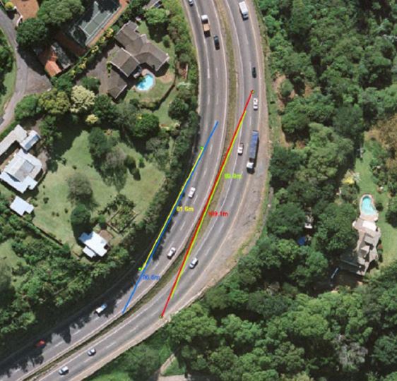
Figure 1: Sight distance top corner (Near Pioneer Rd) (Source: KZN DOT GIS)
Westbound: Slow Lane - 61.6m (Yellow), Fast Lane - 96.6m (Blue) Eastbound: Slow Lane - 109.1m (Red), Fast Lane - 89.9m (Green)

Figure 2: Sight distance near top corner (Source: KZN DOT GIS)
Westbound Slow Lane 97.1m (Purple), Eastbound Slow Lane 76.7m (Cyan)
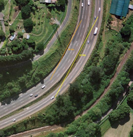
Figure 3: Sight distance bottom corner (near Richmond Rd) (Source: KZN DOT GIS)
Westbound Slow Lane 90.0m (Orange), Eastbound Slow Lane 121.8m (Yellow)
Vehicle break-downs and accidents on other main roads and freeways are easily visible enabling other motorists to slow down and take evasive action, which is often not possible on Field's because the continuous sharp curvature.
If one considers that at 80 kilometres per hour:
![]() a vehicle is travelling at 22 metres per second; and
a vehicle is travelling at 22 metres per second; and
![]() the reaction time when seeing a road obstruction is 2 seconds; and
the reaction time when seeing a road obstruction is 2 seconds; and ![]() the braking distance at that speed is approximately 55 metres.
the braking distance at that speed is approximately 55 metres.
The above do not leave much room for error to avoid an accident, and in rainy conditions an accident is inevitable in such situations.
The combination of a steep downhill gradient and the sharp curve, coupled with unfamiliar surroundings, the potential fatigue of long distance drivers, darkness, and rain makes for a very dangerous situation on Field's Hill. This is compounded by mechanical failure or load instability which often occurs when a heavy vehicle is subject to sudden a sudden swerve or heavy braking.
In summary, Field's Hill suffers from serious the geometric design problems which make it unsuitable in terms of current design standards. The speed limit on this section of the M13 should be reduced to 60km/h and drivers must be required to further reduce their speed according to road conditions.
Steep terrain always means many gear changes for heavy vehicles. Gear changes require increased driver concentration and reduce the driver's awareness of his surroundings. The Hellberg compiled "Comparison of Vehicle Safety on the M13 Fields Hill vs the N3 Toll Route" (Appendix G) concludes that a driver travelling down Field's Hill will perform up to 213% more gear changes than one on the N3.
Traffic density up and down Field's Hill in peak traffic hours is substantially higher than it is on the toll route. This factor alone substantially increases the probability of accidents.
Recovery of the accidents is practically complicated and extremely dangerous to perform as there is little to no shoulder on the eastbound carriageway and only two lanes. Truck accidents on the the eastbound carriageway have sometimes resulted in the closure of the route for an entire day while recovery teams try to manoeuvre in the narrow roadway.
Truck descents on the downhill carriageway frequently endanger the adjoining residential properties. Residents living in properties along the M13 frequently bring complaints of noise pollution caused by exhaust brakes and poorly maintained vehicles.
Heavy vehicle accidents where the safety barriers are unable to restrain the vehicle result in trucks leaving the roadway and falling into adjoining properties thereby endangering lives and private property.
Every year millions of Rand are wasted and thousands of hours of productivity are lost as a result of accidents on Field's Hill restricting the flow of traffic between the Highway area and the rest of eThekwini.
The greater Pinetown area is the largest single contributor to eThekwini Metro's industrial sector and any negative impact on the job soaking growth potential of this sector should be minimised.
Truckers interviewed by the Road Traffic Inspectorate have said the reasons they use the M13 is to avoid the toll fee but also to avoid the weighbridge at Marianhill. Truckers who are concerned about being, or are, overloaded are then choosing to use the M13 instead of the safer N3, and are thus endangering M13 traffic for the reasons outlined in section 5 (Safety).
The National Department of Transport estimates that 60% of the damage done to roads in South Africa is as a result of overloading of heavy vehicles. i In a related report (extract provided as Appendix A), the CSIR has found that:
"Research in the USA and South Africa has shown that damage to the road by axle loads exceeding the legal limit, increases out of all proportion to the loads: for example, an axle carrying double the legal load may cause from 4 to 60 times as much damage as one legal axle load, depending on the condition of the structure and type of road."
The same report attributes the remaining 40% of damage done to roads to correctly laden heavy vehicles. ii
Mr. Siboniso Mbhele, General Manager - Operations: Durban, KZN Department of Transport, has stated that the KZN DOT is spending a significant amount of money fixing damaged guard rails, and that almost every week there is an accident this road. He further states that regarding road surface rehabilitating, the road requires rehabilitation more often than normal which makes it an expensive exercise. He finally stated that a significant reduction in heavy vehicle traffic would reduce the maintenance burden on the KZN DOT.
One of the potential consequences limiting the use of heavy vehicles on this stretch of road is the effect on deliveries and industry in the area. In order to ascertain the possible implications of applying a restriction limiting vehicles to 16 tonnes Gross Vehicle Mass (GVM) on the both carriageways of the M13 between the off-ramp from the N3 at Key Ridge in the West and Richmond Rd at the base of Field's Hill in the East, various businesses in the area were approached for objections.
Spar, Express Hauliers, TFD, Fast 'n Fresh, SAB Miller were all consulted in writing and none have reverted with objections.
Brackenhill Industrial off Inanda Rd is currently accessed by some heavy vehicles via the M13, and then on Old Main Rd through Hillcrest to Inanda Rd. These trucks would instead be required to use the N3 and can take Polo Pony offramp onto Kassier Rd and then onto Old Main Rs and into Inanda Rd, thus reducing the heavy vehicle usage of the Hillcrest section of Old Main Rd.
In the "Final Report: March 2007 - Proposed N2 Wild Coast Toll Highway Environmental Scoping Study, Public Participation Process" (extract provided as Appendix D), SANRAL representative, Mr Stewart Wilson stated:
"Any heavy vehicle should be on the toll road because that is the national road and it is equipped to withstand that loading. [..] It's quite simple in my book, legislate against any heavy vehicle using any road other than a toll road unless it has a business being there and then you police it."iii
10.2. National Minister of Transport
In response to a Parliamentary question by Mr Gareth Morgan MP, asking the Minister of Transport "whether he will launch any other initiative to minimise the diversion of trucks onto the M13 road", the following was provided:
SANRAL is investigating various options in connection with this road, including the improvement and upgrading of the N3 between Durban and Pietermaritzburg (including the addition of a third lane on both the north and southbound carriageways between Cato Ridge and Town Hill).
(3) As alluded to above under (1), the control and effective law enforcement on the M13, together with the application of load restriction, would minimise any unlawful diversions.iv
The full Parliamentary Question has been included as Appendix C.
11.1. (SANRAL and) National Roads Act
The original National Roads Act of 1971 enabled the national roads to be tolled. This Act was then amended in 1992 to require that an alternative route was available to the public. The wording of this was amended in 1996, and all three acts finally repealed in 1998 by the current SANRAL and National Roads Act, Act 7 of 1998.
The amendments and repeal of the National Road Traffic Acts regarding alternative routes for toll are as follows:
- Section 9 of the National Roads Act, Act No. 54 of 1971
- Section 7 of the National Roads Amendment Act 100 of 1992 (amends the wording of Section 9 of Act No. 54 of 1971)
- Section 10 of the National Roads Amendment Act No. 24 of 1996 (amends the wording of Section 9 of the Act No. 54 of 1971)
All the above legislation is repealed by Act 7 of 1998, the South African National Roads Agency Limited and National Roads Act.
11.2. KwaZulu-Natal Provincial Roads Act
Section 7(2)(a) of KwaZulu-Natal Provincial Roads Act No. 4 of 2001 empowers the Minister, subject to subsections (4) and (7) and by notice in the Gazette, to:
"declare that any road, section of a road or any route within the Province is a main road, district road or local road and, subject to national legislation, may restrict the usage of a main road, district road or local road to specified categories of vehicles"
The responses from the Minister of Transport alluded to in 7.2 and SANRAL in 7.1 recommend that measures are taken to restrict heavy vehicles to national roads.
Additionally, on the basis that KZN DOT already is over spending annually on road maintenance requirements [Mbhele], the budget could be spent wisely on other infrastructure programs and projects. It would be prudent to consider reducing the damage caused by both overloading and accidents to Field's Hill by compelling heavy vehicles to utilize the higher standard, safer and cost effective alternate route N3.
The combination of the safety concerns, the maintenance burden, and the cost effectiveness of the N3 as an alternative provides a strong basis this report recommends restricting the use of the M13 in this area by heavy vehicles.
Taking into consideration:
1. the lack of any requirement in the South African National Roads Agency Limited and National Roads Act 7 of 1998 that there be an alternate route to the toll road for heavy vehicles; and
2. section 7(2)(a) of KwaZulu-Natal Provincial Roads Act No. 4 of 2001 which empowers the minister to restrict usage of a road to specified categories of vehicles
We hereby recommend:
1. The Minister declares a restriction limiting vehicles to 16 tonnes Gross Vehicle Mass (GVM) on the both carriageways of the M13 between the Kassier Rd bridge at M13 in the West and Richmond Rd at the base of Field's Hill in the East.
2. The Minister reduce the speed limit on Field's Hill from 80km/h to 60km/h to mitigate the dangerous conditions described in section 6.1. of this document.
Footnotes:
i DOT: Overloaded Heavy Vehicles, http://www.transport.gov.za/library/docs/robot/1998/p16-17.html ii CSIR: The Damaging Effects of Overloaded Heavy Vehicles on Roads, http://overload.csir.co.za/pad27/docs/Pad27_A4.pdf
iii Final Report: March 2007 - Proposed N2 Wild Coast Toll Highway Environmental Scoping Study, Public Participation Process, http://www.nra.co.za/content/Appendix%2010.pdf
iv Parliamentary Question 778 of 2009, Minister of Transport,http://www.pmg.org.za/node/17778
Source: http://warwickchapman.com/ . Transcribed from PDF. See here for link to the full report.
Click here to sign up to receive our free daily headline email newsletter